Dinkytown Commercial Historic District

Read about the history and designation of the Dinkytown Commercial Historic District.

Overview

The Dinkytown Commercial Historic District includes commercial buildings that were developed along a streetcar line near the University of Minnesota. This was one of many streetcar commercial areas within Minneapolis and across the country.

  • Location: Properties generally near the intersection of 14th Avenue Southeast and 4th Street Southeast 
  • Neighborhood: Marcy-Holmes, University of Minnesota

Map and guidelines

See the map and design guidelines for this district

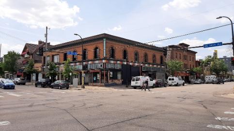
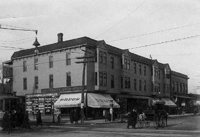
Circa 1905 2023
Dinkytown Commercial Historic District 1905


Dinkytown


Details

Architecture

  • Architectural Style: Various
  • Architect: Various 

Use

  • Historic use: Commercial, Residential
  • Current use: Commercial, Residential 

Construction

  • Construction date: Various
  • Contractor: Various 

Significance

  • Area(s) of Significance: Commerce, Significant Groups, Neighborhood Identity, Architecture, Landscape
  • Period of significance: 1899-1929
  • Date of local designation: 2015
  • Designation: Exterior 
  • Date of National Register designation: Not applicable

Historic profile

The Dinkytown Commercial Historic District includes commercial buildings that were developed along a streetcar line near the University of Minnesota. This was one of many streetcar commercial areas within Minneapolis and across the country.
 
The streetcar was a new mode of transportation. People could move farther from the city center and travel safely and efficiently to work downtown. Retail grew at streetcar stops. Those at home could walk to markets farther from the industrial centers of the city. In the early 1900s, as this intersection developed, the University of Minnesota also grew. Businesses emerged to serve the University community.
 
A railroad corridor runs just south of this commercial hub. It is set within a trench, well below street level. The railroad linked this area to other industries and businesses in Minneapolis and St. Paul. Bridges over the trench connect Dinkytown with the University and surrounding areas.
 
The area continued to grow and change in later years. After World War II, the University student body and the overall economy boomed. The streetcar stopped running in 1954. World events have led to protests and gatherings here. Student interests have influenced the retail options. It continues to be an important place for the University community and beyond. 
Credits

Photo credit

  • Circa 1905 photo: Courtesy of the Minnesota Historical Society 
  • 2023 photo: Minneapolis Community Planning & Economic Development 

Works cited

“Designation Study: Dinkytown Historic District,” 2015

Contact us

Heritage Preservation

Community Planning & Economic Development (CPED)

Phone

612-673-3000

Address

Public Service Building
505 Fourth Ave. S., Room 320
Minneapolis, MN 55415